
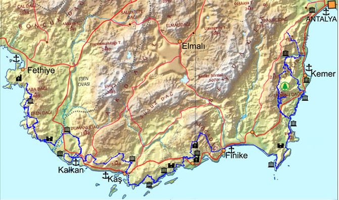
Category (en-gb)
Tekirova – Phaselis
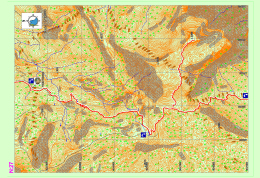
The eastern route of the Lycian road, which forks at Çıralı, passas through various bays on the coast and descends into Tekirova settlement. It progresses for a long while on the plain where the town is located, goes towards north and reaches the Phaselis archeological settlement. Within this section, all needs, such as food, accommodation and shopping can be met in Tekirova.
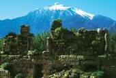
PHASELIS
Phaselis, which is within borders of Tekirova in Kemer district, Antalya province, and draws attention due to its natural beauty as well as its archeological value, was established by the Rhodians around 650 BC. The city was especially rich and powerful during the classical age. Phaselis people, who prospered by means of marine trade, are infamous due to their slyness and deceitfulness.
Tahtalı Dağı – Yayla Kuzdere
The western route of the Lycian road continues to the north from the Beycik settlement and passes across the strait on the west of the Tahtalı Mountain. It runs through centuries-old cedar and juniper trees and snowy hollows. Eventually, the road descends onto a small plain in the middle of which a single house rests. Before arriving at this point, a path that detaches from the road can be taken to access the peak of Tahtalı Mountain.
The small plateau on which the house stands is inhabited during summer, while it is under heavy layers of snow in the winter. It provides potable water by means of the fountain between tree hollows, at the south of the house.
Read more: Tahtalı Mountain – Kuzdere Plateau Map Section 27
Phaselis – Çamyuva – Kuzdere
The road begins from the archaeological settlement of Phaselis and first continues in a route parallel to the sea, then carries on towards the Kuzdere settlement through Turkish pine forests and on the banks of the creek.
Information regarding the archaeological settlement of Phaselis are provided on the page for Section 26. The settlement of Çamyuva is suitable for meeting essential needs such as food and accommodation.
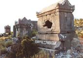
IDYROS
Ancient sources do not contain much information on the ancient city of Idyros. Carl Ritter has stated it is said that “the city which is a ship haven of the ancient ages located around Egber which can be accessed by going north from Phaselis and over the northern slope of Cap Avova, is Idyros Polis”. Skylax has written that the city of Idyros is located between Phaselis (Tekirova) and Lurnateia (Sıçan [Rat] Island). Kipert has indicated that the city is in the bay on the southeastern coast of Kemer Mountain.
In 1977, as a result of the excavations carried out at the back of the Ayışığı facilities for excursionists on the coast in Kemer by the Ministry of Culture and Tourism, the city remains in this area were identified as to belong to the Idyros ancient city. The excavations revealed a Byzantine church and civil architecture structures surrounding it, in addition to tombs from classical and Byzantine periods.
Yayla Kuzdere – Gedelma / Kuzdere – Gedelma Yol ayrımı
The western route of the Lycian road, which parts from the main road, crosses through forests, gardens and other roads from time to time and eventually reaches the settlement of Gedelma. From the Phaselis area, the road first goes through Kuzdere settlement and follows the main road which passes through the Kesme Strait and its canyon, after which it is connected with the eastern route of the Lycian road which reached Gedelma.
Lycian road, which follows the asphalt road that ascends to Gedelma, parts from it after a few hundred kilometers and continues towards the Göynük Plateau from within the forest. The best place in this section where needs for eating, shopping, etc. can be met is the Gedelma settlement.
Göynük Plateau – National Park of Göynük Canyon
Lycian road, which extends from the settlement of Gedelma, goes through small settlements such as Meşeçukuru, etc. and reaches the settlement Söğütçük. The common name of the settlements here is known to be the Göynük Plateau. Lycian road runs parallel to the road below and runs directly on the road below from time to time until it is separated from it and leads down to the Göynük creek.
The route goes through the creek for a while and after the creek is crossed via wooden stairs, it goes up and down a hill into another creek basin, after which a long climb starts. Trekkers who walk below from the Göynük Plateau and towards the canyon should pay attention to the information given below:
Sarıçınar – Hisarçandır
The part of the Lycian road here rises from within the valley in the National Park of Göynük Canyon to the north and turns towards the peak of Sarıçınar Mountain through the end of the valley The road becomes stabilized at the skirts of the mountain and after going through a highland settlement with a few residences, reaches the settlement of Hisarçandır, the official beginning point of the Lycian road.
It should be noted that the Lycian Road continues until the archaeological settlement of Trebenna, which is located near the Çağlarca village in Geyikbayırı, Konyaaltı district, Antalya province and is known to be the last city on the eastern side of the Lycian country. After the marking of ancient road remains which start from the settlement of Hisarçandır, goes through the archaeological settlement of Typella and the skirts of Sivridağ, and reaches the archaeological settlement of Trebenna is completed, the official starting point will become the Akdamlar village, which is nearby, and the maps will be updated in accordance with this.
| Difficulty: Easy Kondition: gering Culture: High Nature: mittel |
Distance: 45 km Duration: 3 h Altitude difference: 200 m |
Diese flache Asphalttour bringt den Radler in das Herz der quirligen Metropole, Kaleici und auch noch weiter Richtung Lara zum beeindruckenden Wasserfall bei Karpuzkaldrian.
Eine von jedem zu bewältigende Tour. Die Straßen im Stadtbereich weisen zeitweise hohes Verkehrsaufkommen auf.
Achtung die bezeichnete Strandbude des Startpunktes wurde auf 22 umnumeriert!
Kas is the last county town located on the south-west cost of Antalya. Antiquity name of Kas was Antiphellos (facing Phellos). As written on ancient sources; Antiphellos means “the extension of Phellos on sea” or the “coast of Phellos (stony place)”. Antiphellos is now a village located on the north of Kas and called Cukurbag.


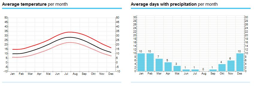
Average Weather in Kaş
Hot season / summer is in June, July, August .
Most rainfall (rainy season) is seen in January, February, October and November.
Kas has dry periods in April, May, June and July.
On average, the warmest month is July.
On average, the coolest month is January.
November is the wettest month.
June is the driest month.

Climate of Turkey
Surrounded by high mountains and open seas, Turkey is a cornucopia of natural wonders. Apart from that, Turkey is noted for its climatic diversity ranging from the Mediterranean to oceanic to continental climates.
The northern regions of Turkey have an oceanic climate whereas the southern areas are affected by a temperate Mediterranean climate. The continental climate reigning in the internal regions makes one experience four seasons in one day.
The southern regions which are popular among tourists particularly in summer and the central and northern regions of Turkey which are in demand rather in winter are popular for their cultural heritage as well as the variety of touristic and sports facilities.
Subject to a variety of climates, Anatolia is also rich in flora and fauna. The habitat of numerous varieties of flora and fauna alongside magnificent forests, Turkey, is worth visiting any season of the year.
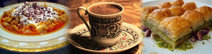
One of the greatest cultural legacies of the Turks who played a major role in the beginning and development of the history of civilization and undertook the first great migration bringing along their values and culture to the Anatolian lands is the Turkish cuisine.
The Turkish cuisine, which had originated from the blending of the Asian, European, Middle Eastern and African cultures and evolved under the influence of the Seljuk and Ottoman Cuisines over the centuries, offers thousands of various dishes and delicacies.
Turkish cuisine evolved long before the Common Era, during the times of hunting and gathering. To provide the hunters with delicious and savory food the women of the time developed various dishes by trial and error and discovered the spices that added flavor.
Lycia’s History - A Struggle For Freedom
The history of Lycia is a story of fierce struggles against those who sought to invade and dominate it, as it was a very desirable region. It appears that Greek efforts to colonize Lycia during the first millennium B.C. were largely unsuccessful even though there were several Athenian expeditions.
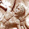 |
The first recorded instance of Lycian resistance fighting occurred around 540 BC when the Persians under the commander Harpagos overran all Asia Minor during the rule of Cyrus II (The Great). The Persians attacked the Lycian capital city of Xanthos and the Xanthosians put up a heroic fight. In the end however, they chose mass suicide over surrender. The men of Xanthos gathered their wives, children and possessions in the acropolis and set fire to all before rushing out fighting to die to the last man. Herodotus of Halicarnassos reports: |
"The Persian Army entered the plain of Xanthos under the command of Harpagos, and did battle with the Xanthians. The Xanthians fought with small numbers against the superior Persians forces, with legendary bravery. They resisted the endless Persian forces with great courage, but were finally beaten, their womenfolk, children, slaves and treasures into the fortress. This was then set on fire from, below and around the walls , until destroyed by conflagration. Then the warriors of Xanthos made their final attack on the Persians, their voices raised in calls of war, until every last man from Xanthos was killed."
Shopping in Kaş

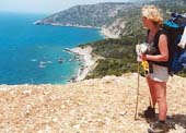
The Lycian way is a 509 km way-marked footpath around the coast of Lycia in southern Turkey, from Fethiye to Antalya. The Lycian Way is a coastal walk and mild temperatures mean it can be walked throughout the winter months.
According to the Sunday Times the Lycian Way is one of the ten most beautiful long distance hikes of the world.
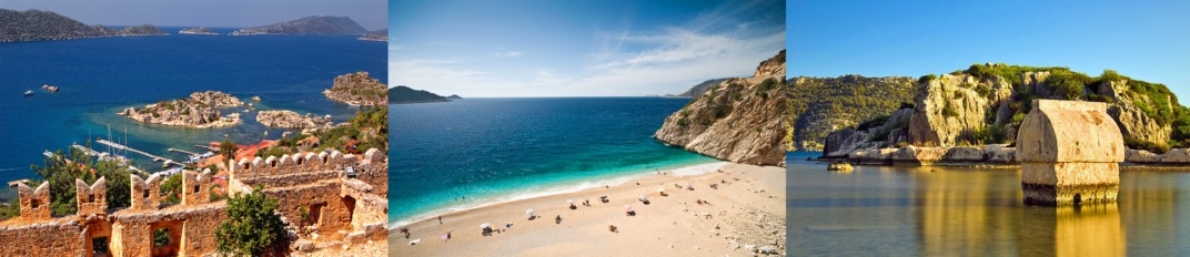
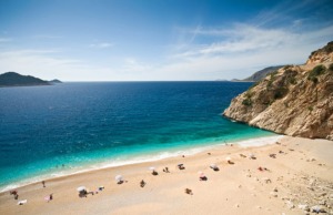
| Kaputaş Beach One can reach this beach from Kas via the scenic Kalkan road by 20 minutes drive. There is a long stair way down to this sandy beach with white-crested waves and magnetizing turquoise color sea.There are no facilities in the beach and the open secret about the stunning turquoise color is the snow-white pepples covering the sea floor. |
 |
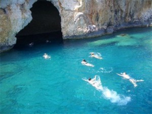
| Blue Cave The Cave was first discovered in year 1972. It is one of the most famous anchoring points of tour boats around Kas, with a 50 m length, 40 m width and 15 m height. It was a habitation for the seals in the past. Because of the narrow entrance the sunlight fogged in through the sea creating joyfull lighting effects and reflections inside the cave walls and ceiling, It is very close to Kaputas Beach and only 18 km to Kas. |
 |
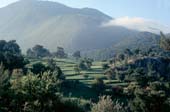
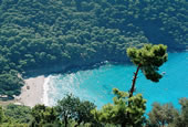
CIRALI resort of Kemer, of Antalya catches people's attention with "sun, sea and natural beauties" as well as the historical richness. At South end of the city lies the ancient city of Olympus, and in the north west there is the Yanartas (Chimera).
The pearl of Antalya, Cirali's coastline is 3.2 km in length. And its width ranges between 50 to 100 meters. The beach rises in a gentle slope from the sea. On both ends it is limited with rocks. Cirali's coastline is made of generally fine-grained structured high-quality sand. At South end through the ancient city of Olympus, a stream passes and merges with the sea.
With your private car:
Drive from Antalya towards the Kumluca-Kas direction turn left on the sign for Cirali 7 km after Tekirova.
With Bus
You may take either the Cicek tour or Antalya tour buses traveling from Antalya intercity bus station to the direction of Kumluca Kas and get off at crossroads of Cirali. You can come to Cirali taking the Shared Taxis there.
By Plane
Come to the intercity bus station of Antalya from the airport and then you can come Cirali by Cicek tour (Çiçek Tur) or Antalya tour busses.
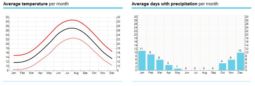
Cirali region has a Mediterranean climate. Summer rain is quite rare rains, the weather is usually open, clear and sunny.
Sea water is heated and can swim towards the end of April until November. 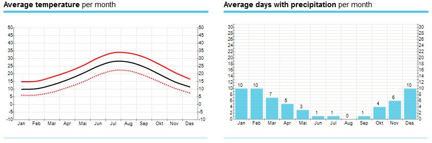
There serves seaside restaurants, pergolas, fast-food type garden cafés at the Olympus coast and in the town center of Cirali .
People who eat In Ulupinar may attaste grilled food , appetizers and salads, pancakes and melon ice cream.
Ones who may have the picnic possibility consume the foods left in the cold water that has soon gained the natural coldness.
Beach restaurant in the center of Olympos and Çıralı coast localities, gazebos, garden cafes serving fast-food type.
Great seafood restaurant in Cirali, cucumber, squid stew stew, meats, olive oil, pancakes, kebabs, pizzas you can eat your appetite.
You may the explore the lost city walking along a different route each day from Cirali which is in the center of East Lycian walking ways or you may swim in the sea in deserted small bays.
You can have breakfast with completely natural foods, under the orange and pine trees. Also by renting a car daily you may travel to Phaselis - Arycanda - Myra in the near vicinity or you can go to the sunken city Kekova.
In order to drive to Olympos from Antalya-Finike road it should be turned at Ulupinar where there is the sign plate for ruins.
A narrow but the exquisite beautiful road leads us right to the beach of Olympos. In order to reach the ruins one should cross the brook and walk a while on the beach then the brook banks are came across of which runs through Olympos.
The path that runs along the brook will lead us into the ruins.
Olympos reOlympos region is located on the coastline of Cirali that is 3.2 km-long. The ancient city of Olympus is located just behind the coastline. There are tree houses and accommodation facilities within walking distance to the region.
A small peaceful Mediterranean resort and fishing town on the beautiful Turquoise Coast of Turkey, Kalkan has not been touched by mass tourism. More sophisticated than the usual resort town, Kalkan appeals to travelers looking for more than a “sun and sea” holiday. According to the Sunday Times, Kalkan attracts the kind of visitor who would also enjoy Tuscany or the Dordogne. The Guardian likens the town to “the Italian Riviera minus the poseurs.”
Because of its great charm, Kalkan has a growing number of perennial visitors who say the town is the only holiday destination they would choose to visit repeatedly. There is simply no other town quite like Kalkan along Turkey’s coast.
"Mouse" and "Snake" Islands in Kalkan Bay
Kalkan curls snuggly around a historic harbour sheltered at the foot of the towering Taurus Mountains. (Read more about the geography of the region at our Lycia website here) The town overlooks a beautiful bay in which islands seem to magically float upon the shimmering sea.
Narrow streets twist down to the harbour, lined with old whitewashed villas with shuttered windows situated alongside small local specialty shops and restaurants in historic buildings. Overhead hang original carved Ottoman Greek timber balconies garlanded with thick masses of brilliantly coloured bougainvillea cascading to the streets below. It is a very special place with a unique atmosphere.
How to reach Kalkan
Food & Cuisine Kalakan
Sightseeing in Kalkan
History of Kalkan
About Patara
How to reach Patara
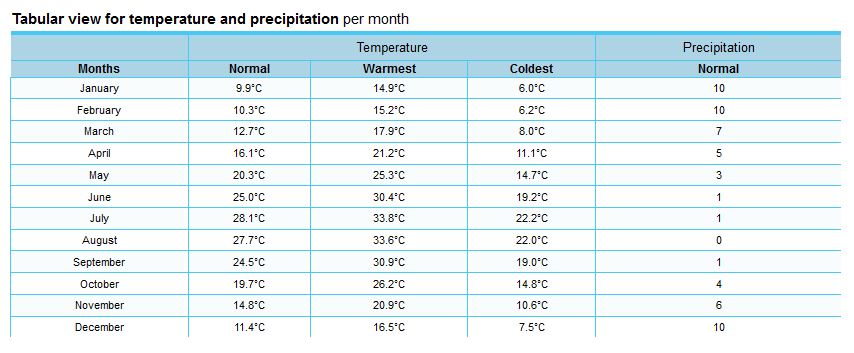
Klima & Temperaturen Patara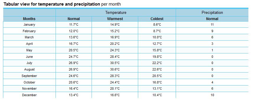
Food & Cuisine Patara
Sightseeing in Patara
Subcategories
Accommodation Article Count: 0
Tours & Activities Article Count: 1
Tours, trips Article Count: 1
Boat Tours Article Count: 0
Trekking Article Count: 0
Blue Cruise Article Count: 0
Discover Lycian Article Count: 34
|
The Lycian way is a 509 km way-marked footpath around the coast of Lycia in southern Turkey, from Fethiye to Antalya. The Lycian Way is a coastal walk and mild temperatures mean it can be walked throughout the winter months. According to the Sunday Times the Lycian Way is one of the ten most beautiful long distance hikes of the world. The route is graded medium to hard; it is not level walking, but has many ascents and descents as it approaches and veers away from the sea. It is easier at the start near Fethiye and gets more difficult as it progresses. We recommend walking the route in spring or autumn; February-May or September-November; summer in Lycia is hot, although you could walk short, shady sections. The route is mainly over footpaths and mule trails; it is mostly over limestone and often hard and stony underfoot. On the first part of the route, and in Patara, Kalkan, Kas, Myra, Finike, Adrasan, Olympos, Cirali and Tekirova, you can stay in pensions or small hotels. On other nights, you may stay in a village house, or camp out. There are plenty of camping places with nearby water mentioned in the book; you do not have to ask permission to camp out.
Highlights of the Lycian Way include: |
|
Lycian Way Article Count: 31
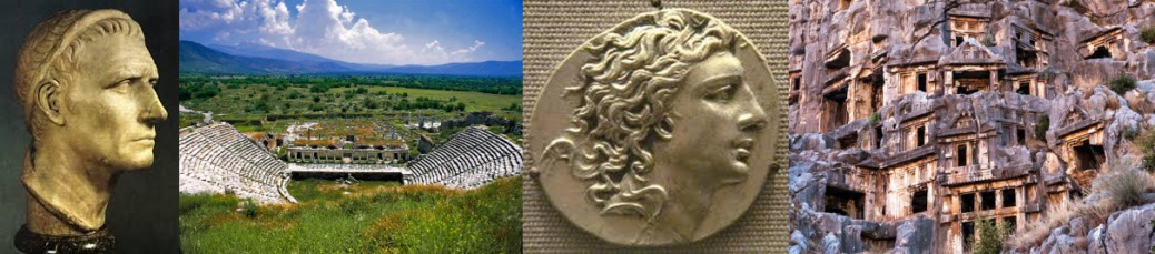
| Teke peninsula, which is located between the Antalya and Fethiye gulfs in the Mediterranean region, was named as Lycia in ancient geography. The southern border of the region is its coast to the Mediterranean Sea, while its eastern, western and northern borders changed throughout the history. According to the ancient writers, Beydağları which start from the west of Antalya and extend to southwest, Akdağ range and their extension to the northwest defines the northern border of Lycia. In the famous epic poem Iliad, Homer states that the Lycians, which were commanded by Glaucus and Sarpedon, supported the Trojans against the Achaeans. |
Lycia came under the dominance of the Persians after 545 BC and supported the fleet that was formed by the Persian King Xerxes for the conquest of Greece in 480 with 50 ships. The Persian occupation ended when Alexander the Great crossed the Bosphorus to Anatolia and defeated the Persians in 333 BC in the Battle of Granicus. After the death of Alexander the Great, Lycia came under the dominance of Ptolemaic dynasty in Egypt, which descended from the general Ptolemy, from the year 309 BC for 100 years; this is known to be the period in which Lycian language was forgotten and replaced with Ancient Greek.
The region has been ruled by the Syrian King Antiochus III between the years of 197 BC and 167 BC. Lycia received its independence from the Roman Empire in 167 BC. During this period, 23 cities united and formed the Lycian League, of which the capital city was Xanthos. According to inscriptions and ancient coins the League had its monetary unit.
Strabo states that the six biggest cities of the Lycian League were Xanthos, Patara, Pinara, Olympus, Myra and Tlos. The Miliarium Lyciae, which is the map of the Lycian region with distance units and routes connecting the settlements, is the oldest road map known. During the Roman Empire period, the League did not lose its function and reached maximum level of prosperity during this time. The city populations were around 5,000 and the total population of the region was approximately 200,000. The borders were pushed further as to include Kaunos (Dalyan) in the northeast.
Around the middle of 5th century, there were 34 cities ruled by the Proconsul of the Lycian State. The region between Demre and Kaş was the most populated area in Lycia. The amount of settlements per kilometer is nearly 30 in this region. Introduction of Christianity to Lycians did not occur until the visit of St. Paulus to Myra and Patara at his third missionary journey between the years of 53 and 57. Methodius of Olympus was the first known bishop of Lycia and he was executed in 312. The Byzantine period between 4th and 7th centuries was the period in which Christianity was adopted and many churches were built in the region.
One of the most prominent changes that occurred during the said period was the start of monastery settlement constructions, especially in the mountainous areas of Demre. Monasteries were very important points of power which had influence on the economic and public life. The monastery life in Lycia started as early as the 5th century. The fact that many large churches were built during the 5th and 6th centuries indicates that the population of the region was very high during the said period.
Most of the Lycian coast is formed of rocky terrain. This type of topography has allowed for natural harbors to be shaped at some locations. Strabo has expressed that the Lycian coastline is rough and difficult to pass through, while the harbor is very well-equipped. Maritime trade, which existed in the region since the Bronze Age, became diversified in the following periods and lasted until the Roman and Byzantine Periods. Purple dye, cedar wood, olive oil, wine and sponges are the key goods that are produced in Lycia. According to ancient sources, high quality and soft sponges can be harvested at Antiphellus and the area surrounding it. In addition, the quality of the cedar wood in Lycia, which is used in shipbuilding is rather high as well.
The harbors in Lycia can be named as Idyros, Phaselis, Corycus, Olympus, Posidarisus, Melanippion, Gagae, Phoinikos, Andriaca, Simena, Teimussa, Aperlae, Antiphellus, Kalamaki, Phoinike, Patara, Pydnai, Arymnessos/Perdicia, Calabantia, Karmylassos, Telmessus, Krya, Lisse and Lydai, respectively from east to west.
Of these harbors, Andriaca and Patara is distinguished from the others in that they possess political and economic power, in addition to being an internationals trade point. By virtue of its local traditions and distinctive architectural style, the region is the most interesting area in Anatolia; the cities of the region are generally located on the coasts and the valleys of Xanthos and Arycandus, which are considered to be the core of the region. Some of the texts that belong to the Lycians, who were known for having their own language and alphabet, were translated into modern languages; most of these are epitaphs.
The region of Lycia consists of cities of large, medium and small scale, port cities, military zones, farm settlements and towers. Most of the visible remains in the region belong to the Roman and Byzantine periods. The most encountered types of remains in the traditional settlements concentrated in the mountains are olive oil and wine workshops, and agricultural terraces. These rural settlements, in which most of the population lived, provided food for both themselves and the large cities.
The residential structures in Lycia are generally divided into four groups. The first group consists of adjacent residences in which each room has its own entrance. The second group is made up of stand-alone residences of one or two rooms in rural settlements. Both types of residences in these groups are generally two-storey houses that are located collectively or closely within walls of the settlement. The third group consists of single-storey residences with two to four rooms in agricultural areas of which some has courtyards, cisterns and workshops, while the fourth group is made up of residences of mostly rich people in rural areas, which are built as rooms surrounding a courtyard which is positioned in the middle.
Natural disasters and epidemics that occurred in the region have deeply affected the lives of those in the cities. The most prominent of these are the earthquakes that occurred in the years 141, 240, 385, and 529, and the plagues that happened in the year 542 and the period between 1346 and 1347. Due to the blights that were suffered in the coastal regions, the settlements in the inland areas came into prominence. Emperor Constans II fought the Arabians in 655 on the coast of Phoenix with the fleet he personally commanded. After being defeated, the Emperor managed to survive by way of the self-sacrifice of a young soldier. After this battle, the Arabians began navigating freely near the Mediterranean coasts.
In 802, the regions of Lycia and Caria were occupied by the Abbasids. During the 10th century, Lycia and the whole of the Mediterranean region were under the domination of the Byzantine Empire. Turks acquired access to Lycia after the Seljukian Sultan Kılıç Arslan II defeated the Byzantine army. After 1204, the whole of Lycia came under the domination of Turks.
Mountainbike tours Article Count: 1
Vacation Spots Article Count: 37
Kaş Article Count: 7
Olympos/Çıralı Article Count: 6
Kalkan Article Count: 6
Patara Article Count: 6
Kekova Article Count: 6
Demre/Hoyran Article Count: 6
Demre/Hoyran